Showing posts with label Cartography. Show all posts

Thursday, March 7, 2013

Don't Wipe Your Nose With This Map

by Stephen J. Gertz


Evelyn Mulwray: It's a handkerchief!
[slap]
Jake Gertz: I said I want the truth!
Evelyn Mulwray: It's a map…
[slap]
Evelyn Mulwray: It's a handkerchief…
[slap]
Evelyn Mulwray: A handkerchief, a map.
[More slaps]
Jake Gertz: I said I want the truth!
Evelyn Mulwray: It's a handkerchief AND a map!

The Travelling Handkerchief  has come to town, Fairburn's Map of the Country Twelve Miles Round London by E. Bourne, printed on calico, 590 x 540 mm, in 1831, a scarce, early handkerchief map.

The map is circular, and reaches Teddington in the south west, clockside to Norwood, Harrow on the Hill, Chipping Barnet, Dagenham, Purley and Kingsston, wherever they are. I'm in Los Angeles, clockside to Westwood, harrowing on Barrington, Pico and Sepulveda; what do I know? This cartographical Kleenex™ is decorated by vignette views of Chelsea and Greenwich Hospitals in the bottom corners, and a banner heralding the title is held aloft in an eagle's beak.

Washington D.C. based on
Samuel Hill's engraving of Andrew Ellicott's plan.
Printed in Boston, c. 1792.

Handkerchief maps date back to the late 18th century. Examples featuring the plan for Washington D.C. werre sold as "'an authentic plan of the Metropolis of the United States,' advertised as an accurate guide for the prospective purchaser of lots but also as 'a very handsome ornament for the parlor or counting room" (Luria, Capital Speculations: Writing and Building Washington, p. 14). These handkerchief maps are believed to have been printed in Boston in 1792 in connection with "the sale of lots in the new 'Federal Town'" (Works Progress Administration, Washington: City and Capital, p. xiv).

Map of the Baltic theatre of the Crimean War
Paris, Dopter, c.1855.
Engraved map, printed on silk. 650 x 610mm.

Map of the Baltic Sea during
the Crimean War, when the British and French
sent their fleets to blockade St Petersburg.
It is decorated with vignettes of St Petersberg,
Kronstadt, naval scenes and French and British coat-of-arms.

During the 19th century, the British Army's Quartermaster-General Department in India issued handkerchief maps of Delhi and Attock for use by their troops, and they were published as souvenirs during the Crimean War.

The Absent-Minded Beggar.
London, the Daily Mail Publishing Co. Ltd, c.1899.
Linen handkerchief printed in blue, 460 x 470mm.
Printed handkerchief published by the Daily Mail
to rise funds for the "Soldiers' Families Fund"
after the outbreak of the Second Boer War (1899-1902).

Guildhall Library in London has an example of The Travelling Handkerchief in its collection and of another handkerchief map scarcity, An Illustrated Map of London, published in 1850.

Anonymous.
London and its Environs for 1832.
Engraving on cotton. 915 x 890mm.

Handkerchief maps were issued to U.S. Air Force servicemen during WWII as escape maps if shot down over enemy territory. On acetate rayon, linen, or silk, they were lightweight, waterproof, hard to tear and tough to disintegrate; they were able to take a beating yet still fulfill their purpose. The British also issued handkerchief maps to their air force crews and ground troops in all theaters of operation.

The Helen Louise Allen Textile Collection at University of Wisconsin has sixteen mid-20th century handkerchief maps of U.S. states, Canada, the 1939 World's Fair, etc. in its collection.

Surviving eighteenth and nineteenth century handkerchief maps in collectible condition are quite rare.

Jake Gertz: My nose is bleeding, gimme your handkerchief.
Walsh: Forget it, Jake, I'm lookin' for Chinatown. It's on here somewhere.
__________

BOURNE, E. The Travelling Handkerchief. Fairburn's Map of the Country Twelve Miles Round London. London: John Fairburn, 1831. Engraved map printed on calico. 590 x 540mm.

Howgego 216 (3).
__________

The Travelling Handkerchief and other British handkerchief map images courtesy of Altea Gallery, with our thanks.

Image of Washington D.C. handkerchief map courtesy of George Washington University GW Magazine, with our thanks.
__________
__________

Thursday, November 8, 2012

The Wind Cries Mary In 1650

by Stephen J. Gertz

 Tabula Anemographica seu Pyxis Nautica Ventorum Nomina Sex Linguis Repraesentans.

After all the jacks are in their boxes,
and the clowns have all gone to bed,
you can hear happiness staggering on down the street,
Blown by a wind-rose, hand-colored, a grand old spread.


The above wind chart, Tabula Anemographica seu Pyxis Nautica Ventorum Nomina Sex Linguis Repraesentans, was originally published as Plate I in Jan Janssonius' Amsterdam, 1650, Atlas Maritimus, containing thirty-three maps of the waterworld. It's  one of the earliest and most significant anemographic, or wind rose, charts to appear in the seventeenth century. A scarce example of the 1750 fifth impression (above) is being offered by Ketterer Kunst in their Wertvolle Bücher auction November 19-20, 2012.

This visually stunning map represents a transitional point in the perception of direction, from the feel the wind to the sight of a compass.

Early seagoers in the Mediterranean defined direction by the names the various winds and the points from which they blew, an idea that can be traced back to Homer, who identified four cardinal winds; as navigation and cartography improved, more winds were added.

This chart identifies thirty-two winds and a host of various wind systems. Each of the winds is identified by several different names, in Greek, Latin, French, and Dutch.

Each wind is married to contemporary compass points - north, west, east, and south - and the more sophisticated circle system with degrees.

Each wind is, furthermore, personified by a figure bearing the racial characteristics associated with the region or direction represented. The upper left quadrant, for instance, representing north, depicts bearded Germans or Scandinavians. The upper right, representing east, shows beardless dark skinned faces. The beardless and pale skinned figures in the lower left and right, representing west and south, are less distinguishable but may represent indigenous Americans and Greeks.

Anemographic maps were functional objects and valuable reference tools. Early navigators, referring to the directions as winds, might sail by the north wind. This was  practical when trade winds dictated ocean commerce. A warm wind from the south, for example, might suggest that certain routes, closed for part of the year, were now open.

A navigator would have used this chart to, amongst other reasons, compare different names for directions. Here, he could figure out what various sailing logs and navigation books were referring to.

Nautical charts existed in the seventeenth century yet most navigation was performed using Pilot Books that contained vague instructions, i.e. Follow the south wind for three days before turning left with the eastern wind.

Yet an old mariner's habits persist. While sailing through '60s Counterculture, Jimi Hendrix asserted that the wind blowing through popular music in May, 1967 cried, "Mary," and thereby charted a new direction in the air. Rock guitarists have been following that breeze ever since.


__________

[LOTTER, Tobias Conrad, engraver (1717-1777]. Tabula Anemographica seu Pyxis Nautica Ventorum Nomina Sex Linguis Repraesentans. Ausburg: 1750. Fifth edition, re-engraved.
__________

Image courtesy of Ketterer Kunst Auctions - Hamburg, currently offering this 1750 impression, with our thanks.
__________
__________

Tuesday, June 5, 2012

Welcome To Marriage Island, The Isle of Connubial Blitz (1765)

by Stephen J. Gertz


Welcome Isola del Maritaggio (Marriage Island), the Too-Much-Reality TV show! I'm your host, Al Fresco, sitting in for Silvio Berlusconi who is on special assignation. 

Each week contestants enter the island through the ports of Love, Bad Advice, or Self-Interest but once on the island it is impossible to escape! You may, however, if things get tough, claw your way over to Divorce Peninsula on the north side of the main island or, if fortune smiles, Widowhood Peninsula on its West coast where the Bridge of Sighs of Relief provides comfort for the superficially bereaved.


Challenging hot-spots on the main island include the Provinces of the Jealous, the Unhappy, the Incompatible, and the Great Province of Cuckolds. With all the hustle and bustle don't worry about missing a trek up and through the Mountains of In-Laws; it's unavoidable. Afterward, you can bathe in the River Chaste.

Lover's Isle.

Contestants aren't told but they can avoid Marriage Island altogether simply by sailing around it to Lover's Isle. It's one of those things best discovered on their own particularly after the knot is tied. We keep our mouths shut - unless, of course, they're indiscreet or we need to spike the ratings.

Bigamy Island.

Masochistic contestants who can't get enough of Marriage Island can opt for a lifetime on Bigamy Island, a spin-off series with no end to story complications; it'll run forever as long as the homicide rate stays under control.

Note horned cuckold at right.

If you would like to become a contestant, you will be sent, for a small four-figure non-refundable deposit, Carta Topografica dell'Isola Maritaggio, a satiric travelogue written by Eustache Le Noble (1643-1711), who led a dissipated life, was jailed and fell passionately in love with a beautiful grocer-woman who was doing time in the same prison. This slight volume originally appeared in French as Carte de l'isle de mariage in 1705, and was translated into Italian and published in 1765. Please allow 10-14 days for delivery.


 But for now, buona fortuna e addio from Isola del Maritaggio!
__________


LE NOBLE, Eustache. Carta Topografica dell'Isola Maritaggio di Monsieur Le Noble per la Prima Volta Tradotta Dal Francese in Italiano. Cosmopoli [Italy]: n.p., 1765. First Italian edition. Octavo. 40 pp. One folding map.
__________

Map and titlepage images courtesy of Altea Gallery, currently offering this item, with our thanks.
__________
Speaking of marriage:

Novelist Richard Brautigan's Unrecorded One Day Marriage Certificate Surfaces.
__________
__________

Wednesday, April 11, 2012

Three Strange And Beautiful 16th Century Fantasy Maps, Another From 1617

By Stephen J. Gertz

MUNSTER, Sebastian. [Europe depicted as a Queen].
Basel, c. 1580. German edition. Colored. woodcut (260 x 160mm).
MCC I: 6.
During the late sixteenth century, a few cartographers designed and published a handful of maps with anthropomorphic countries and continents, with animal as well as human forms.

Sebastian Munster's created this famous example, a map of Europe that depicts the continent as a queen. The head represent Iberia, Denmark the left arm and Italy the right with Sicily an orb in her hand. The British Isles are shown, but not integrated into the figure. The map originally appeared in Munster's Cosmographei (1550).

BÜNTING, Heinrich. Asia Secunda pars Terræ in Forma Pegasir.
Magdeburg, 1581. German edition. Colored woodcut (300 x 370mm).

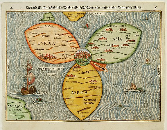
In the famous fantasy map depicting Asia as Pegasus, the winged horse of Perseus, the head is Turkey and Armenia, the wings Scythia and Tartary, forelegs Arabia, hind legs India and the Malay Peninsula. The map appears in Bünting's Itinerarium, in which the author, a theologian, rewrote the Bible as a travelogue, with other fantasy maps including the World as a cloverleaf.

BÜNTING,H. Die gantze Welt in ein Kleberblatt
Magdeburg, ca. 1581. Colored woodcut.
Shirley, World 142.

 And here it is. This extraordinary curiosity is referred to as the Clover-leaf, for obvious reasons. Heinrich Bünting's design was inspired by the trefoil form of the arms of Hanover, his native town. Despite the map's unusual appearance the fact that Jerusalem appears at the centre leans strongly on the tradition of medieval world maps. Bünting's work Itinerarium Sacrae Scriptura...was essentially a theological commentary with other maps of great curiosity.

VAN DEN KEERE, Pieter. Leo Belgicus.
Amsterdam, 1617. Colored engraving.
Van der Heijden, Leo Belgicus 4.2.

Pieter Van Den Keere's Leo Belgicus is, perhaps, the most celebrated example of cartography as patriotic expression. The lion had long been a national symbol of Holland and Belgium. Indeed, most of the coats-of-arms of the countries' seventeen provinces feature a lion. The map was a statement of unity, since at the time the seventeen provinces comprised a single nation, although under the control of Spain.

Van den Keere (Kaerius) was one of the most skilled Flemish engravers of the early seventeenth century. The Leo Belgicus is perhaps his finest work, its rich ornamentation includes three couples along the bottom in the characteristic dress of Friesland, Holland, and Belgium.
__________

First three images courtesy of Altea Gallery Antique Maps, Sea Charts, Atlases & Globes, with our thanks.

Image of Leo Belgicu courtesy of Barry Lawrence Ruderman Antique Maps, with our thanks.
__________
__________

Wednesday, March 7, 2012

Old "New" Map Charts Europe's Current Financial Woes

by Stephen J. Gertz


Seignor Italy continues to  enjoy la dolce far neite despite obvious pressures to do something, anything; niete has gone too far. Señora Spain is smoking a cigarette during  a siesta, off to the side as if the Pyrenees offer protection from the rest of Europe's woes. As a measure of how lame it has become, Greece is lumped in with and indistinguishable from the Balkan nations and is crushed under the weight of her prosperous neighbors to the north, France and Germany, who dominate the Continent as Ottoman Pashas in tricorn and Pickelhaube. Speaking of which, Turkey calmly watches from the sidelines as a houri in repose lazily smoking a hookah. Debt is not the only thing higher than a kite; ambitious pipe-dreams cloud the upstart's waking hours. Great Britain, by the way, is  an island with its own problems and glad to not be a part of Europe's.

2012? 


No, 1870.

In that year, French illustrator and caricaturist Paul Hadol (1835-1875) created Nouvelle carte d'Europe dressée pour 1870, a biting satire of the Franco-Prussian War that has endured as a comic masterpiece representing the ferocious power politics of contemporary Europe, caricaturing the Continent's national stereotypes. While the map is undated, it was undoubtedly published in the wake of the fall of Louis-Napoleon III and the Second French Empire in September 1870 after  his surrender to the Germans at the Battle of Sedan.


Only 20 centimes at the time of its publication, a genuine copy (not reprint) in very good condition of the 1870 first issue now costs approximately $3,000.

Got the shorts? Borrow the money from Greece. If they can't loan it to you, ask Angela Merkel. If she's not home, call Sarkozy. If he's cozy with Carla, give Ben Bernanke a buzz. If Big Ben's a bust, there's always Warren Buffet. He won't bail you out but he's got a rule, so if there's any fairness left in the world you'll have a little extra dinero in your pocket at his and Donald Trump's expense.

In Hadol's map, Trump's the guy with the weird hair posing as the King of Denmark and firing everyone, another delusional monarch whose time has come and gone.
__________

[MAP - POLITICAL SATIRE - EUROPE]. Nouvelle carte d'Europe dressée pour 1870. Paris: Imprimerie Vallee, n.d. [1870]. Hand-colored lithographed map, 24.5 x 38.5 cm, on sheet with text (42 x 58.5 cm). 

See: Dormeier, Humoristisch-Satirishe Europakarten von 1848 bis zum Ersten Weltkrieg..., pp. 525-542, no. 3.
__________

Image courtesy of Asher Rare Books, with our thanks.
__________
__________

Tuesday, January 31, 2012

Art of the Map at Bloomsbury

by Stephen J. Gertz

FRIES, Laurent. Tabu. Nova Orbis. Lyons, 1535.

Bloomsbury-London is offering 100 lots of historic maps during its Books and Maps sale, today, Tuesday, January 31, 2012. Amongst the many cartographic beauties, primarily regional and national,  are six world maps of artistic and historical interest.

Laurent Fries' Tabu. Nova Orbis (1535) is a woodcut Ptolemaic (geocentric) world map, later hand-colored, depicting Greenland as a long peninsula stretching from Scandinavia into the Atlantic Ocean. It features an elephant or mammoth at upper left, and five enthroned kings sitting in N. Europe, China, India, with two in Africa. The title banderole is unfurled at the top.

HONDIUS, Henricus. Nova Todas Terrarum Orbis Geographica
ac Hydrographica Tabula.
Amsterdam: Jan Jansson, 1641.

Henricus Hondius' Nova Todas Terrarum Orbis Geographica ac Hydrographica Tabula (1641) is an engraved, later hand-colored double-hemiphere world map showing California as an island and part of the north coast of Australia - put the shrimp on the barbie in Santa Monica, Mate. It features a small celestial globe at top, and four portrait medallions of Julius Caesar, Ptolemy, Mercator, and Hondius at each corner with allegorical figures of the four elements in between.

ORTELIUS, Abraham. Aevi Veteris, Typus Geographicus.
Amsterdam, 1592.

Aevi Veteris, Typus Geographicus (1592), by the great Abraham Ortelius, is an  engraved and hand-colored classical world map within an elaborate strapwork border containing the title above and the four known continents in corner medallions.

ROGERS, William. Double-Hemisphere World Map.
John Wolfe, 1598.

William Rogers' engraved and hand-colored Double-Hemisphere World Map (1598) possesses a strapwork surround and the name Iehovah at center-top. It was issued as one of the title pages to the 1598 English translation of Jan  Huyghen van Linschoten's Itinerario (John Huighen van Linschoten, His discours of voyages into ye Easte and West Indies: devided into foure bookes).

SCHEDEL, Hartman. Secunda Etas Mundi.
Nuremberg: Anton Koberger, 1493.

Secunda Etas Mundi (The Second Age of the World, 1493) by Hartmann Schedel (one of the first cartographers to use the printing press) is a Ptolemaic world map taken from the first Latin edition of Schedel's Nuremberg Chronicle, which featured the first maps of many cities and countries. In later hand-colored woodcut, the map is surrounded by twelve headwinds, and supported at upper left and right and lower right corner by Ham, Seth, and Japhet of the Old Testament. At left are seven panels depicting strange and fantastical human beasts.

VISSCHER, Nicolaes J. Orbis Terrarum Typus de Integro
in Plurimus Emendatus, Auctus, et Icunculus Illustratus.

Amsterdam, 1657.

Orbis Terrarum Typus de Integro in Plurimus Emendatus, Auctus, et Icunculus Illustratus (1657) by Nicolaes J. Visscher, the Dutch cartographer most famous for his maps of New Netherland (New York), New England and the Atlantic Seaboard, is a hand-colored engraving, a double-hemisphere with California as a peninsula, and showing parts of the coast of Australia and Van Dieman's Land (i.e. Tasmania). Diagrams of the solar system appear at upper and lower center, and scenes with allegorical figures representing the four known continents illustrate each corner. Celestial spheres are featured in the right hemisphere at bottom, and descriptive text about recent discoveries is found in the left hemisphere.

These are gorgeous maps, with estimates ranging from $400 - $550 (Rogers) to $4700 - $6300 (Hondius).
__________

Images courtesy of Bloomsbury Auctions, with our thanks.
__________
__________

Friday, November 18, 2011

An American Folk Art Masterwork: Hand-Stitched Celestial Map (1863) at Christie's

by Stephen J. Gertz


On May 23, 1863, Hattie E. Rogers of Oneida County, New York, sewed her name  to a just completed project.

That project was a recreation in needlework of Elijah J. Burritt's, A Celestial Planisphere, Or Map of the Heavens (New York: 1835).

A very large hand-stitched celestial map (1435 x 2390mm), its stars are composed of white cloth, some labeled in contemporary ink manuscript, and depicted to five orders of magnitude, sewn onto a Cambridge blue background composed of seventeen panels of cloth, the crease folds corresponding with the correct latitude and longitude astral co-ordinates. The verso of the top edge is lined with linen and has five small hanging loops. Two small paper labels are stitched to the left- and right-hand sides.

Hattie E. Rogers was the sister of Henry C. Rogers, author of History of the Town of Paris, and the Valley of the Sauquoit (Utica, 1881). He mentions her several times in book, where she is described as having served as a music teacher in the school at Paris, NY in 1878.

What is extraordinary about this piece is that is provides evidence that not all American women of the era were needlepointing samplers. Hattie E. Rogers was an educated woman interested in science and astronomy.

Part of Christie's - London South Kensington Fine Printed Books and Manuscripts, including a selection from the Malcolm S. Forbes Jr. Churchill Collection and Photobooks from the Calle Collection, November 28, 2011 sale 3013, this American folk art celestial map is estimated to sell for £2,000 - £3,000 ($3,206 - $4,809).
__________

Image courtesy of Christie's, with our thanks.
__________
__________

Tuesday, April 26, 2011

A Masterpiece of Maps Goes Digital At Cambridge

By Nancy Mattoon


Proof Sheet For The Map Of Lancashire,
Engraved For John Speed's 1611

Theatre of the Empire of Great Britaine.

(Image Courtesy Of Cambridge University Library.)

Anglophiles who are planning to watch the Royal Wedding of HRH Prince William and Kate Middleton on April 29, 2011, now have a new opportunity to gain insight into the history and geography of the kingdom over which the future monarch and his bride will reign. Cambridge University Library has digitized a set of proof sheets for the first comprehensive atlas of Great Britain, first published 400 years ago.

Detail From The Proof Sheet For A
Map of
Britain at the time of the Saxon Heptarchy.
(Image Courtesy Of Cambridge University Library.)

John Speed’s Theatre of the Empire of Great Britaine is one of the world’s finest cartographic treasures. Anne Taylor, head of the Map Department at Cambridge University Library, notes that, "Although the Library holds several copies of the published atlas – including a first edition – it is the hand-coloured set of proofs produced between 1603 and 1611 that is one of its greatest treasures."

Detail From The Title Page
For the Finished Atlas.

(Image Courtesy of Occidental College.)

There are only five known sets of the proof sheets in existence worldwide, and each of them differs greatly in composition. The proof sheets were purchased by the Cambridge Library in 1968, and are now considered priceless. They consist of a single sheet for each county of England and Wales, plus a map of Scotland and each of the four Irish provinces. The maps were engraved by the great Flemish artisan Jodocus Hondius, who worked for 10 years to complete the intricate copper plates used for printing the atlas.

A Sampling Of The Heraldry Included In Speed's Atlas.
(Image Courtesy of Occidental College.)

Born in Farndon, Cheshire, in 1551 or 1552, John Speed was a historian as well as a cartographer. He wrote a Historie of Great Britaine, which was also published in 1611, but is today remembered much more for his cartography than his writings. Speed did not do all of the surveying for his maps himself, but the maps which have a "scale of passes" in the completed atlas are those whose geography he observed first hand. He also relied to a degree on the works of earlier cartographers, especially the county maps of the great surveyor Christopher Saxton. As Speed himself wrote, "I have put my sickle into other mens corne."

Speed's Map of The Town Of Rochester.
(Image Courtesy of Occidental College.)

In the finished atlas, but not on the proof sheets, there are descriptions of each town which was mapped.These were often adapted from William Camden’s Britannia, a topographical and historical survey of Great Britain and Ireland, and are not always flattering. The entry for Cambridge states, "This province is not large, nor the aire greatly to be liked, having the Fenns so spread upon her North, that they infect the aire far into the rest." The entry for the city of Lincoln includes two major events in that city's history, "In the Citie of Lincolne two great conflicts have bene fought. The first by Ranulph Eearl of Chester and Robert Earle of Gloreshter against King Stephen in defence of Maude the Empress where King Stephen was taken and hence had to Bristow, and there layd in Irons. Anno 1140. The second was fought by King Henry 3 against his disloyall Barons, where Barons with the French were put to flight and therein dyed the Earle of Perch with 400 knights."

Detail Showing The Prehistoric
Monument Of Stonehenge.

(Image Courtesy of Occidental College.)

Anne Taylor points out a significant element omitted in the proofs by cartographer Speed: "You can see there aren't any roads on the maps. The bridges over rivers would have been a major transport route through the countryside back in those times. Roads would not have been properly constructed." She notes that these maps were not meant for the same purpose as road maps today. "People would not have used maps to get to places. They would have gone to a place and then asked for directions to the next place. These maps may have been sold individually but they would have been bound in a large volume that you wouldn't have been able to take out with you. They were more like a reference book. Queen Elizabeth’s advisers may have used the maps for strategic purposes." It is known that in the 1640's, Speed's atlas was used to create battle plans by both sides in the English Civil War.

Speed's Map Included Portraits Of
English Citizens Of Various Ranks.

(Image Courtesy of Occidental College.)

Speed's country maps were among the first to attempt to show the territorial divisions created by local governments. But his town plans are considered his greatest contribution to British cartography. The atlas was the first printed collection of British city plans, and at least 50 of the 73 locales included in the atlas had never previously been mapped. The Theatre of the Empire of Great Britaine was an immediate success: the first print run of around 500 copies sold quickly, and many later editions followed. It remained the source of all folio maps of Britain well into the 18th century. If the proof sheets whet your appetite for more, there are several web sites which have digitized editions of the finished atlas. One of the most comprehensive was created by Professor Maryanne Cline Horowitz of Los Angeles's Occidental College, the source of many of the images in this post.
__________

Wednesday, March 2, 2011

When the Heavens Converted to Christianity

by Stephen J. Gertz

Engraved title page: The Christian Firmament:
The twelve apostles, formerly the twelve signs of the Zodiac

Has this ever happened to you? You go to bed, and the patterns formed by celestial bodies in the night sky are as they have been since ancient times: Orion's Orion, Capricorn's Capricorn; Ursa Minor's Ursa Minor, Cygnus is Cygnus.

But when you wake up in the morning Orion is Joseph, father of Jesus; Capricorn is St. Simon the Zealot; Ursa Minor is Solomon's Crown; and Cygnus is St. Helen, who I've never heard of aside from her role as Angry Volcano in The Washington State Story. The constellations have undergone an identity crisis; who's who, what's what? You don't recognize the fifty-four you're familiar with.

I hate when that happens. And, apparently, so, too, did people one day in 1627.

Constellation IX: St.Helen, formerly Cygnus.
At that star-crossed time, Julius Schiller (1580-1627), a lawyer - a lawyer! - and cartographer from Augsburg, Germany, published Coelum stellatum Christianum (Christian Starry Heavens), an atlas of celestial maps. Within, Schiller  replaced all of the pagan constellations named after the signs of the Zodiac and figures from Greek mythology with those from the New Testament and Christianity. The twelve zodiacal constellations, for example, were renamed for the twelve apostles - Taurus the Bull became St. Andrew, etc. Eridanus became the Red Sea; Argo became Noah's Ark; and Andromeda became the Sepulcher of Christ. A massive, forced conversion had taken place.

Constellation VII: The Three Kings, formerly Hercules.

That the heavens of God and Christ were corrupted by pagan influence was too much to bear; something had to be done.

Constellation I: St. Michael the Archangel, formerly Ursa Minor.

Schiller’s new system, however, was too radical a change and never gained acceptance and traction; the constellations had been doing just fine for two thousand years and the religious imperative was not felt by contemporary scientists - nor anyone else, for that matter. excepting the  Jesuits and highly pious members of the laity. It's similar to the failure of the metric system in the U.S.: Despite the Metric Conversion Act of 1975, we like our ounces, pounds, quarts, inches, and miles, thank you very much, they work. Now leave us alone. Take your liters and leave.

Constellation XIX: St. Gabriel the Archangel, formerly Pegasus.

But Coelum stellatum Christianum was valuable for other reasons beyond trying to wrest the stars out their pagan context and place them in accordance with Christian theology. Twenty-four years after Johann Bayer's Uranometria (1603) - at the time, the best star atlas - was published, Schiller corresponded with  Bayer and included corrections and additions to the stars and their positions. Coelum stellatum Christianum was, for instance, was first celestial atlas to include the Great Nebula in Andromeda. It was, upon its publication, the most accurate star atlas yet produced despite its biblical gloss.

Constellation Va: St. Sylvester, Pope, formerly Bootes.

The plates in Coelum stellatum Christianum are slightly smaller than those in Uranometria but presented in the same order.  A printed table lies opposite each map, and the stars are identified by Arabic numbers, rather than Bayer letters. Schiller provides two descriptions for each star, one referencing  the original pagan constellation figure, the other its new Christian identity.

Star chart I by Caspar Scheck.

"In considering Schiller's atlas it is convenient to distinguish between the scientific content and the religious orientation. Viewed simply as a collection of celestial maps it was the best available until Hevelius published his atlas 60 years later. Schiller was not himself an astronomer, but a cartographer who used the observations of others. His atlas, essentially a revision of Bayer's Uranometria, was based on the latest - the most extensive and the most accurate - astronomical information. Among his authorities were Tycho Brahe, Franciscus Pissero's revision of Tycho's catalogue as published by Grienberger, Galileo's telescopic observations of the Pleiades, and Simon Marius' telescopic observations of the Andromeda nebula. Kepler, it must be remembered, had not yet issued the expanded version of Tycho's catalogue and it was not apparent that he would ever do so (in fact, the Tabulae Rudolphinae appeared in the same year, 1627).

Star chart II by Caspar Scheck.

"Schiller's atlas was the outcome of the ideas and work of several men, extending over a quarter of a century. The need for a new atlas, with revised star positions and constellations, was argued by Bayer, Schiller, and Raymond Minderer, a doctor of medicine also at Augsburg. Bayer then undertook the astronomical revisions while Schiller, in correspondence with the Jesuit astronomers Johann Baptist Cysat, Paul Guldin, and Jesuits philologist and historian Matthew Rader, converted the Greco-Roman constellations into Judeo-Christian ones. Wilhelm Schickard, the astronomer and professor of Oriental languages at Tübingen, supplied the Arabic letters and star and constellation names. Kaspar Schecks positioned the stars on the copper plates, German historical painter Johann Mathias Kager drew the constellation figures, and Lucas Kilian engraved them. Finally Jakob Bartsch [Kepler's son-in-law] supplied various astronomical tables and, after Schiller's death, supervised publication" (Warner, D.K. The Sky Explored, pp. 229-230).

Despite Schiller's best efforts, ultimately the fate of Coelum stellatum Christianum and its Christianized constellations rested with the Old Gods. Their opinion was swift and stern.


__________

SCHILLER, Julius. Coelum Stellatum Christianum Ad majorem Dei Omnipotentis, Sanctaeq Eius fam Triumphantis quam Militantis Ecclesiae Gloriam. Onductis Gentilium Simulachris, eidem Domino et Creatori Suo, postliminio quasi restitutum, Humili Conatu et Voto. Julii Schilleri Augustani Vindel V.I.D. ; sociali opera Joannis Bayeri IC Uranometriam novam, priore accuratorem, locupletioremq suppenditantis Matthiae Kageri, picturam primo concinnantis ; scalpello, qua imagines Lucae Kiliani, qua stellas Casparis Schecksii. [Augsburg]: Augustae Vindelicorum, Praelo Andreae Apergeri, 1627.

First edition. Oblong folio. (12 1/4 x 14 1/2 in; 313 x 367 mm). [4], 134, [1, errata], [1, blank] pp. Engraved title page, fifty-one celestial maps including  biblical constellation figures engraved by L. Kilian after M. Kagerone, one  engraved plate (Arabica Nomina). Includes Jakob Bartsch's Tabulae constellationum synopticae and Tabula canonica, and updated states of Schecksius' star charts.
__________

Images courtesy of David Brass Rare Books, with our thanks.

The Linda Hall Library of Science, Engineering, and Technology has a Constellation Index of the originals and Schiller's Christian replacements along with digital reproductions of each of Schiller's maps.
__________
__________

Wednesday, November 17, 2010

Map of Duck Soup's Imaginary Fredonia Discovered

by Stephen J. Gertz

LAURIE, R[ichard] H[olmes]. Fredonia. Or the United States of North America;
including also Cabotia, or the Canadian Provinces; The Western Territory To
the Pacific Ocean' And the Northern Part of the Mexican States.

An 1848  map of Fredonia, the nation whose bitter conflict with Sylvania  was the subject of a celebrated 1933 Hollywood documentary, has surfaced and will be auctioned at PBA Galleries on November 18, 2010. It is estimated to sell for $4,000 - $6,000.

The nation was, until recently, thought to be, like the lost continent of Atlantis, strictly legend, the documentary a complete fake.

"Hail! Hail! Fredonia!"

At the time of the documentary's release, the  political and economic crisis that gripped Fredonia and Sylvania required appropriate commentary. Cynicism, buffoonery, anarchy, disrespect for political institutions and leadership ran high. The Laws of the Administration of Fredonia were a scandal. The absurdity of government, diplomacy, and war as an answer to anything came sharply into focus.


Duck Soup is one of the great political documentaries yet with a title nonsensical in the context of the events it limned. In contrast to  Duck Soup, The Sorrow and the Pity is a Loony Tunes cartoon. Things were certainly afoul in Fredonia, but more like a firkee of turkeys.  Duck Soup concerned itself with the failure of diplomacy, the growing escalation of belligerence between the great nations of Fredonia and Sylvania, and the effect that open hostilities would have upon their respective nations and the world stage.

Curiously, however, there has been doubt about whether Fredonia and Sylvannia actually existed or  were simply convenient constructs for the documentarians to provide context for the issues at stake.


Not too long ago, scholars discovered that Sylvania was, indeed a real place; it was located on a light bulb. Sylvania was known as The Land Where Ideas Begin, based upon the anatomical fact that all ideas originate in the brain's hypothalamus as a tiny bulb that lights up at that eureka moment when a notion evolves into the hint of an idea.

Another major find recently turned up at a garage sale, the national flag of Sylvania.

Flag of Sylvania.

The conflict with Sylvania began when Fredonia, known as the Land Where Ideas Start, claimed that it had more good ideas in an hour than Sylvania had in a month, and that all of Sylvania's ideas were bad, particularly the one about  tax cuts and health care only for the wealthy or well-connected, which Fredonia claimed its own but was stolen by agents of the Sylvanian intelligence service.

Chicolini and Pinkie, master spies.

The Chicolini Affair brought matters to a head. Chicolini and Pinkie, officers in Sylvania's  CIA, turned out to be double agents working for Fredonia's leader, the Hon. Rufus T. Firefly. Ambassador Trentino of Sylvania considered this casus belli and, in concert with a round of face slaps between Firefly and Trentino, led to the first shots fired, despite the intervention of Fredonia's matriarch, Mrs. Gloria Teasdale, The Mother of Her Country, and the object of Firefly and Trentino's romantic attention.

Rufus T. Firefly, Mrs. Gloria Teasdale, Ambassador Trentino,
and Vera Marcal, an Alaskan politico-provocateur-adventuress.


Fredonia.  Real or imaginary? What was this strange nation? Where was it located?

The shots heard 'round the world.

Now we know.
__________

LAURIE, R[ichard] H[olmes]. Fredonia. Or the United States of North America; including also Cabotia, or the Canadian Provinces; The Western Territory To the Pacific Ocean' And the Northern Part of the Mexican States, London: R.H. Laurie, 1848. Engraved map, hand-colored in outline. 64.5x97 cm. (25¼x38"). On 24 panels, mounted on linen, folding into 9x5" original(?) cloth case with gilt title.

"This map bears a legend explaining the origin of the word "Fredonia" to designate the United States of North America, 'hence Fredonian or Frede, a native of, and Fredish, of or belonging to the same territory'" (PBA catalog).
__________

Image of map courtesy of PBA Galleries.

Sylvania logo and bulb image courtesy of Sylvania, with our thanks.
__________
__________
 
Subscribe to BOOKTRYST by Email