 |
| MUNSTER, Sebastian. [Europe depicted as a Queen]. Basel, c. 1580. German edition. Colored. woodcut (260 x 160mm). MCC I: 6. |
During the late sixteenth century, a few cartographers designed and published a handful of maps with anthropomorphic countries and continents, with animal as well as human forms.
Sebastian Munster's created this famous example, a map of Europe that depicts the continent as a queen. The head represent Iberia, Denmark the left arm and Italy the right with Sicily an orb in her hand. The British Isles are shown, but not integrated into the figure. The map originally appeared in Munster's Cosmographei (1550).
 |
| BÜNTING, Heinrich. Asia Secunda pars Terræ in Forma Pegasir. Magdeburg, 1581. German edition. Colored woodcut (300 x 370mm). |
In the famous fantasy map depicting Asia as Pegasus, the winged horse of Perseus, the head is Turkey and Armenia, the wings Scythia and Tartary, forelegs Arabia, hind legs India and the Malay Peninsula. The map appears in Bünting's Itinerarium, in which the author, a theologian, rewrote the Bible as a travelogue, with other fantasy maps including the World as a cloverleaf.
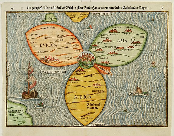 |
| BÜNTING,H. Die gantze Welt in ein Kleberblatt Magdeburg, ca. 1581. Colored woodcut. Shirley, World 142. |
And here it is. This extraordinary curiosity is referred to as the Clover-leaf, for obvious reasons. Heinrich Bünting's design was inspired by the trefoil form of the arms of Hanover, his native town. Despite the map's unusual appearance the fact that Jerusalem appears at the centre leans strongly on the tradition of medieval world maps. Bünting's work Itinerarium Sacrae Scriptura...was essentially a theological commentary with other maps of great curiosity.
 |
| VAN DEN KEERE, Pieter. Leo Belgicus. Amsterdam, 1617. Colored engraving. Van der Heijden, Leo Belgicus 4.2. |
Pieter Van Den Keere's Leo Belgicus is, perhaps, the most celebrated example of cartography as patriotic expression. The lion had long been a national symbol of Holland and Belgium. Indeed, most of the coats-of-arms of the countries' seventeen provinces feature a lion. The map was a statement of unity, since at the time the seventeen provinces comprised a single nation, although under the control of Spain.
Van den Keere (Kaerius) was one of the most skilled Flemish engravers of the early seventeenth century. The Leo Belgicus is perhaps his finest work, its rich ornamentation includes three couples along the bottom in the characteristic dress of Friesland, Holland, and Belgium.
First three images courtesy of Altea Gallery Antique Maps, Sea Charts, Atlases & Globes, with our thanks.
Image of Leo Belgicu courtesy of Barry Lawrence Ruderman Antique Maps, with our thanks.
__________
__________

No comments:
Post a Comment